Above are the commonly found farm land of the coastal plain.
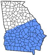
The Coastal Plain is the largest region in Georgia. It is the leader in agriculture, and is very flat, without many hills or valleys. Many rivers that flow down from the Appalachian mountains flow through here, but they turn from fast flowing, rapid mountain rivers, into slow, wide streams.
The Coastal Plains was under water in pre-historic times. This is the reason that the terrain there is very flat. The Coastal Plain accounts for 60% of the state, but doesn't account for nearly that much of the population, around 1,500,000. However, the Coastal Plain is the main agricultural region. They grow peanuts, pecans, peaches, pine trees, okra, squash, etc... Major cities in the area consist of Savannah, Augusta, Millegeville, Macon, and Columbus. The Coastal Plain is the hottest and most humid region in Georgia. The average annual precipitation is 46 to 58 inches.The main rivers in the Coastal Plain are Savannah, Flint, Altahama, and Oconee. Some of the minor rivers are Withlacoochee, Satilla, and the Alapana. The lakes are lake Walter George, Seminole, Blacksher, and lake Worth. The tourist attractions are the barrier islands, waterfalls along the Fall Line, coastal towns, and the Okefenokee swamp. The natural resources that they have are Phosphate, Phosphate concentrate, limestone, sand stone, kaolin, and bauxite.
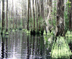
Okefenokee- Located in the southeast are of Georgia, it is the largest swamp in North America. It is nearly 700 miles. This swamp became a national refuge center for animal species in 1937 thanks to president Franklin D Roosevelt. This swamp is named after the Seminole word 'Trembling Earth' This swamp is also fresh water.
Fall Line- The Fall Line separates The Piedmont and Coastal Plains and runs 20 miles across Georgia. It is called the fall line for the abundance of waterfalls. The major cities that sit on the fall line are Macon, Columbus, Augusta and Millegeville. The waterfalls in this area provide hydroelectric power for the cities near them.
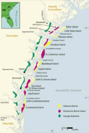
Barrier Islands- The major Barrier islands are St. Simmons, Jekyll, Tybee, and Cumberland. These islands protect the inland from coastal storms and hurricanes. They are all connected to the mainland by bridges like the Sidney Lanier bridge that connects Brunswick to the entrance of Jekyll island. The islands attract a lot of tourism.
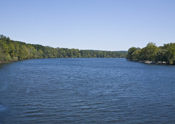
Savannah River- The River is a natural barrier between Georgia and South Carolina. It flows southeast, emptying into the Atlantic ocean. It provides drinking water, hydroelectricity, and is used for recreational purposes. This river begins at lake Hartwell.
